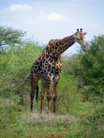
Click the photo of the giraff above to see an album of photos. Close the window to return to this page.
Read previous Botswana and Zimbabwe with Drifters
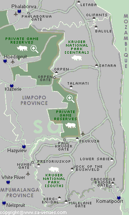
Our Drifters tour had brought us to many more game parks than we had anticipated and we had seen innumerable animals, but Kruger National Park still held allure as one of the premier parks in Southern Africa. Before leaving Cape Town we had arranged for a three day guided tour of Kruger Park, provided by Old Vic Backpacker Lodge in Nelspruit, close to Kruger. We got a lift to the airport in Johannesburg the day after finishing our Drifters tour and caught a minibus to Nelspruit.
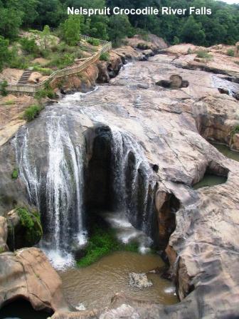
We spent a leisurely day in Nelspruit visiting the Botanical Gardens where we admired the waterfalls on Crocodile River and picked out the native trees and flowers we had seen on our trip so far. The Botanical Gardens were within walking distance to the big Riverside Mall complex, which includes a casino, a convention center and a hotel. We took advantage of the internet and caught up on our neglected emails. Animals, unlike humans, know to avoid the hottest times of the days. Therefore to best view wild animals, you have to operate on their time schedule. That means getting up at dawn for the first game drives and waiting until late afternoon for another. That was our schedule every day in Kruger, as it had been in game parks in Namibia, Botswana and Zimbabwe..
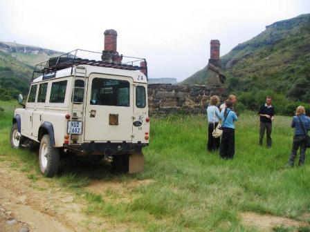
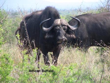
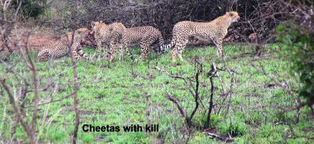
Ray and I left Nelspruit in a Toyota 2WD SUV with our guide Piet Botha. Piet took up guiding as a retirement project and over the past few years has driven over almost every inch of the park. He knew the best places to sight each different kind of animal, but the animals proved more elusive than we had hoped. The rains had started filling water sources in the forests that are normally dry.Ray and I left Nelspruit in a Toyota 2WD SUV with our guide Piet Botha. Piet took up guiding as a retirement project and over the past few years has driven over almost every inch of the park. He knew the best places to sight each different kind of animal, but the animals proved more elusive than we had hoped. The rains had started filling water sources in the forests that are normally dry. The animals no longer had to come to the traditional waterholes as regularly so we were lucky to see as many animals as we did. We did see elephants, zebras, African Buffalo, lots of antelope, especially impala, wildebeest, warthog, giraffes, huge crocodiles beside river, but no leopard. Piet did try his best to find a leopard for us, but this elusive animal remained hidden. Our most exciting sighting was four cheetas enjoying a meal of a recently killed impala. One good effect of the rains is the increased number of birds in the park and Piet was very good at identifying many of them for us. We stayed overnight in rondavel cabins in two camps in Kruger, Lower Sabie Camp, on the Sabie River and Pretoriuskop Camp, both very comfortable. At both places we had a night game drive in large vehicles equipped with spot lights which passengers used to sweep the roadsides looked for the shine of animal eyes.
We returned to Nelspruit just long enough to stay overnight and pick up a rental car the next morning, a tiny pumpkin coloured Kia Picanto. It had a tiny trunk space and laboured up the hills but it ran well and got us where we wanted to go for the next two weeks. Swaziland is a small independent country surrounded by South Africa. It felt like a more African country than South Africa as soon as we crossed the border. We drove south through the mountains, past vast timber farms, seeing few whites. Swaziland is noted for its inexpensive and well-made crafts. We passed a huge outdoor market with at least 100 booths on the entrance to the Ezulwini Valley. We later came back and made several purchases from the vendors.
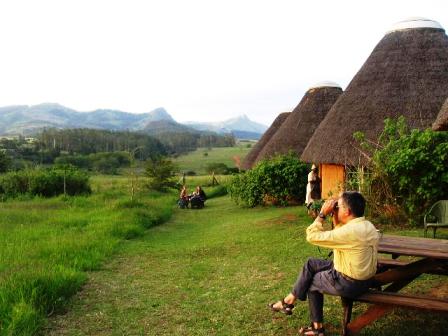
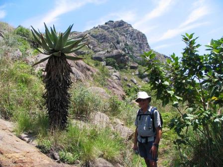
We had reserved a room at a backpack lodge in the Ezulwini Valley, but a fellow backpacker in Nelspruit cautioned us that the lodge had changed hands and the standards had fallen. She suggested we try another lodge in the Mlilwane Wildlife Sanctuary. Sondzela, available to international tourists, was a gem and a real bargain. Mlilwane was the first wildlife sanctuary in Swaziland created in 1950s on a farm owned by Ted Reilly. An extensive system of walking and driving trails allows visitors to get close to the animals, including the Roan antelope, which is being reintroduced to the area. Warthogs, zebra and impala grazed peacefully outside the door of our rondavel and there was a nice swimming pool at the main Sondzela lodge. We elected to buy our breakfast (15 Rand - $2.50 CAD) and dinner (25 Rand) from the lodge. Simple filling meals were cooked by the staff on an open fire in a pleasant clearing in front of the lodge. Hiking maps of the area and information were available at the main Mlilwane Sanctuary Lodge, a few kms from Sonzela. We took one trail that led us up the hills past an old aqueduct built by Micky Reilly in the early 20th C to bring water to his tin mining operation. This was an engineering feat for its time with 27 km of lead pipe and wooden sluice boxes built by hand. Rock cairns that once supported the sluice boxes still stand along the trail. After several hours walking we reached the bare granite summit with a 360 degree view of valley.
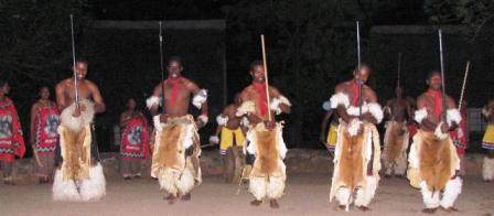
We had a treat one evening while at Sonzela. There was to be a traditional dance and song performance at the main lodge. Several of us piled into a minivan and were driven over by one of the staff, a participant, dressed in full warrior array. A group of about 16 Africans performed several Swazi numbers for a very appreciative audience.
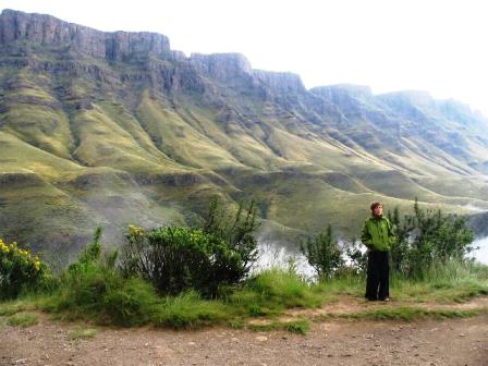
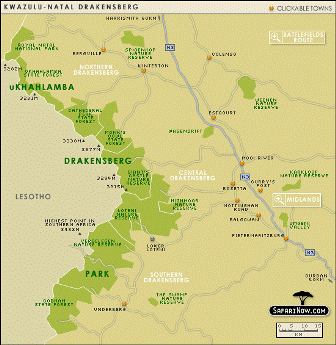
One area we had been looking forward to visiting was the Drakensberg Mountain Range, which forms the eastern border of Lesotho, another small independent country surrounded by South Africa. We planned to do several day hikes in this picturesque area. The stark beauty of the mountains prompted me to investigate how they were formed. The Drakensberg, which means Dragon Mountains in Afrikaans, were formed over milleniums. 200 million years ago desert conditions existed over all of Southern Africa. Incredible quantities of windblown sand formed the last sediments of the Karoo system forming sandstone. Towards the end of this period a cataclysmic geological event occurred pushing molten magma up through the soft Karoo sandstone to form a basaltic lava layer over all of Southern Africa. The top of the lava plain was estimated at 600 M above sea level at that time. Uplifts occurred, raising the summit of the area to 3000 M. The basalt overlay has been weathered by time into a long, high escarpment which the indigenous people called the uKhahlamba, the "Barrier of Spears". This high barrier, rising from the east into the uplands of Lesotho, protected the Basotho people (as Lesotho people are known) from the advances of the Zulu in the 19th C. There is no "other side" to the Drakensberg. Climbing up to the summit of a pass at 3000 M, you are on a plateau bisected by valleys, stretching far into Lesotho. We started our visit to the Drakensberg in the northern end, near the Royal Natal Park. We stayed at the Amphitheatre Backpack lodge and signed up for a guided hiking trip on the Sentinel Trail in the Amphitheatre, a high escarpment flanked by Sentinel (3165 M), and the Western Buttress on one end with Devil's Tooth and the Eastern Buttress (3047 M) on the other side. We could see the Amphitheatre Mountains from the grounds of the backpack but to hike there we had a long drive to the other side of the Sterkfontein Dam, the site of a vulture revitalization program. Vultures depend on dead animals for their food and farming has eliminated most of the wild game in the area. The vultures were existing on a diet of garbage and were found to be suffering from osteoporosis because of the lack of bones in their diet. Farmers in the area now bring any dead livestock they have to the area near the dam for the vultures. The carcasses are cut up allowing the vultures to get at the bone marrow, essential to their diet. On the other side of the dam our driving route took us past the large campus of the University of Free State, and towards Phuthaditjhaba, an area of seemingly endless rows of small concrete houses. These townships were created in the 1980s as a homeland for southern Sotho people (black QwaQwa tribes). This was an apartheid policy that moved 200,000 blacks into an area that was not agriculturally viable and still has little industry.
We walked across the plateau to return via two sets of permanent chain ladders. The ladders were very secure and even had handholds making our descent easier than we anticipated. At the base of the ladders we met a father and two young sons, about 10 and 12 years old, with backpacks coming up the ladders to start a three-day hike in the mountains. We were most impressed. We had intended to stay another night at the Amphitheatre Backpack but left early in disgust. This was the first and only place in our several years of backpacking that loud music has continued until late into the night and entreaties to turn it down or off have been ignored. We journeyed on rather than stay and suffer.
The area boasted a great bakery with a coffee shop and several craft studios. The Ardmore Ceramic Studio sells their colourful, whimsical creations all over world. A teapot with leopards on the lid and handle fascinated me but the small hand decorated birds sold as Christmas tree ornaments were the only items in my price range. We visited the Amasele Fabric Art Studio and bought wall hangings depicting Basutho people from Lesotho in tribal dress. Another popular tourist spot was a rug-weaving studio. The studios all use local artisans to produce many of their designs. We had met fellow Canadians in Swaziland who recommended going to a Drakensberg Boys' Choir School concert. We were able to attend their last Wednesday afternoon concert before the end of their school year. This was a treat. The choir was established in 1967 and now has a multi-racial student population of 83 boys between the ages of 8 and 15 in the boarding school, just a km from Inkosana. Besides music and choir practise, the boys take the usual complement of academic subjects and have physical activities every day. It must pay off for the boys are extremely talented, with several CDs to their credit, and are a delight to see and hear. The concert was a mixture of classical and African numbers, with a few drumming and dance numbers thrown in for good measure.
Another day we drove to Giant's Castle Nature Reserve. It took us longer than we had anticipated, nearly two hours over a terrible potholed road. The area is rich in San rock paintings but only one of the sites is open to the public. A pretty trail 2 km long led to a cave on the side of a mountain. A guide waited to take groups into the cave area and explain the significance of the paintings. They were interesting but not as good as some of the other paintings we had seen on our Drifters tour. There are numerous hiking trails in the area, all well maintained. Giant's Castle Reserve also has a central information center with a restaurant and large cabins for overnight guests. We chose a day hiking trail to World's View. We had a pleasant walk alongside a river and below several low hills, ending at a viewpoint with a good 360-degree view of the area. Sani Lodge in the Southern Drakensberg was our last stop. The backpack lodge is on the only road leading to Lesotho from the Drakensberg side. The Sani Pass Road is a winding, rocky ride up to the Lesotho border at 2865 M. You can drive yourself as far as the South African border, if you dare, but our little Kia could not handle the potholes and rocks on the unpaved Sani Pass Road. The best option is a day excursion in a 4WD jeep. We went with Matthew, a guide from Sani Lodge, four young girls travelling together, two German fellows, one of whom had his 22-month-old daughter with him. We stopped near the bottom of the road at an abandoned trading post where Basothos (Lesotho was formerly called Basutoland) came by foot and on mules to trade wool and mohair for goods. The post closed when the Sani Pass Road was built in the 1960s and vehicles started to go all the way to Lesotho. There are plans, supported by the Basothos, to pave the entire length of the road. Many conservationists fear that paving will diminish the wildlife in the area and will not be kept up any better than the current dirt road is. At any rate, it will be several years before paving reaches Lesotho.
The day started out cloudy and rain started as we started up the Sani Pass. The mud road got worse and worse nearer the top as we manoeuvred through sharp switchbacks. We wondered how larger vehicles like trucks ever got through. At the South African border post, a group of Basotho men, draped in blankets, the preferred cover worn by all the Basotho in this area, passed us on their way down for a day of trading. They were headed for a minibus that travels the Sani Pass road as far as the South African border post. The Lesotho border post was another eight km further. We stopped enroute to get a spectacular view of the mountains above a cloud blanket that covered the valleys below us. The top of the pass brought us into another world of tundra and wide-open spaces. Some say it is like Mongolia. The area was once the summer grazing area for the merino sheep and angora goats that are still kept by the people. With tourism, many families stay all year, braving the snow that falls during the winter months. When a boy reaches 13, he can choose to earn money as a sheepherder for three years. We were warned that the temperature drops at the top of the pass and had come prepared. The shepherds ride small horses, wearing a blanket and a knitted cap like the Nepalese to keep warm. On one of his earlier trips, Matthew discovered one of the boys wearing a blanket embroidered with a crude map of Lesotho. He bought the blanket and kept it with him in the 4WD for warmth.
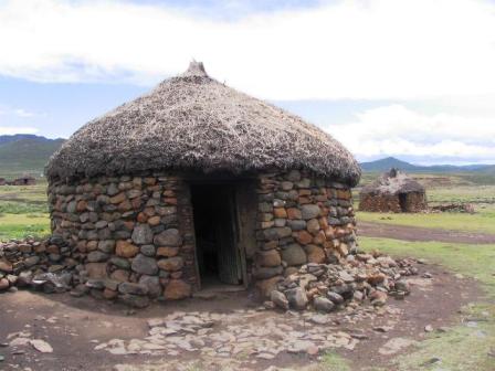
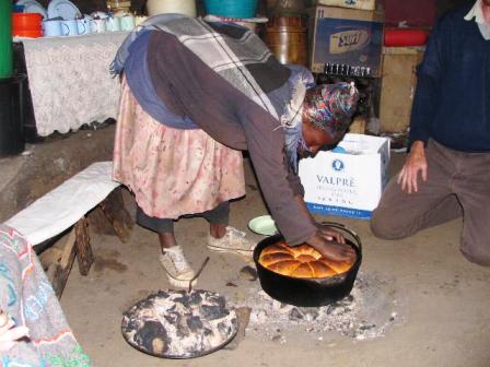
It was still raining lightly when we reached the top so Matthew gained permission from a local woman to eat our pack lunch inside her home. She shared with her four children a simple round thatched roof hut constructed of rocks. One small door facing north gave the only light in the hut. The inside walls were plastered with dung and decorated with designs drawn by her children. A big iron pot with a cover holding smoldering dung coals sat in the middle of the room. Our hostess removed the lid revealing a large loaf of freshly baked bread. She sells the bread pieces to tourists and shepherds for 5 Rand a slice. Our group bought several pieces. After finishing lunch we visited a shearing shed, where men were packing the merino wool from their sheep into 100 kg plus bags. The rain had stopped by then so we had just enough time for a short hike for a glimpse through the clouds of Thabana - Ntlenyan mountain (3482 M), the highest peak south of Kilimanjaro. We had to be back at the South African border before it closed for the day at 4 PM, but that didn't stop us from visiting the Sani Top Chalet. We all had a glass of hot gluwein at the highest bar in Africa at 2874 M. Another time we would love to come and stay overnight at Sani Top to explore more of the area. We set off the next day for a hike to Strumness, a rocky hilltop behind the Sani Lodge. This would have been a much more pleasant route if the rain had not come. We got soaked walking across an open plateau. I would have gladly turned back if we had found an alternate route down to the valley but none appeared. We did reach a cave in time for our lunch and the rain let up enough for our clothes to dry out somewhat so we continued on. The last section was very pretty, beside a river in a small canyon. In better weather we would have been more than ready to jump into the natural pools in the river for a swim. Oh well, rain has to be expected in December in South Africa.
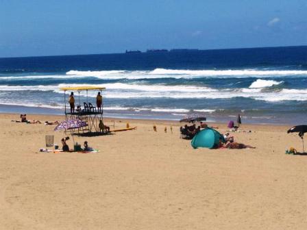
The next day was still raining so we decided it was time to depart for Durban. We drove most of the way in the rain on the first busy roads we had encountered since Johannesburg. We checked into Nomads Backpack that was in a nice part of city near a big shopping mall and woke the next day to clear, blue skies, perfect for exploring Durban. We took the local bus to the Indian market where we managed to buy more curios (souvenirs) and a bag to carry them home. We walked along the harbour front but decided it was more like a beach day. Another bus took us to the Northern Beaches where many families were enjoying the holidays. We spent an enjoyable time watching surfers paddle out and ride back to shore on the waves. We celebrated the end of our trip over dinner at a seafood restaurant, the Ocean Basket, in the mall next to Nomads. We had enjoyed Durban and all of Southern Africa much more than we had expected but it was time to go home. After a short flight to Cape Town, we boarded a plane to Frankfurt. The pilot gave us a treat by making a loop over Table Mountain and the Cape Peninsula, low enough for everyone to get a last look. The plane landed in Frankfurt early the next morning and after a few hours wait we were on our way to Montreal and finally, on a short flight to Ottawa. We will return to discover more of Africa. |
Return to Southern Africa Introduction
Return to Travels
Return to Introduction
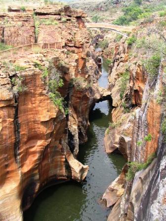 The third day of
our trip we left Kruger to drive through the Blyde Canyon
area. Timber farms of pines and eucalyptus line the roads
leading up to the canyon, which is a favourite tourist
destination. Low cloud and drizzle meant there was no
point going to God's Window for a view but we did have a
good view from Pinnacle Lookout of the canyon, including
Blydepoort Dam, Marepeskop peak, named after a local king
and the Three Rondavels named for the king's three main
wives.
The third day of
our trip we left Kruger to drive through the Blyde Canyon
area. Timber farms of pines and eucalyptus line the roads
leading up to the canyon, which is a favourite tourist
destination. Low cloud and drizzle meant there was no
point going to God's Window for a view but we did have a
good view from Pinnacle Lookout of the canyon, including
Blydepoort Dam, Marepeskop peak, named after a local king
and the Three Rondavels named for the king's three main
wives. 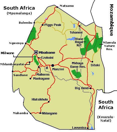
 We drove into a nature
reserve and up a steep winding road that was in the
process of being graded. We parked several km up at the
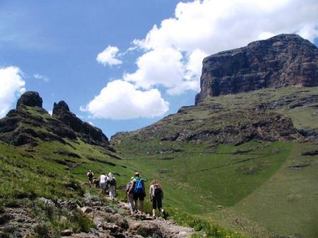
gates of the Sentinel hiking trail and started walking.
The first section of the trail was easy switchbacks but
already gave us great views. Our route to the Sentinel
plateau was up
We drove into a nature
reserve and up a steep winding road that was in the
process of being graded. We parked several km up at the
gates of the Sentinel hiking trail and started walking.
The first section of the trail was easy switchbacks but
already gave us great views. Our route to the Sentinel
plateau was up 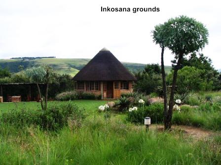 Our next backpack, Inkosana,
in the Central Drakensberg, was a welcome respite. It was
set in beautiful grounds and carefully maintained. We
ended up staying in one of their rondavels for six days,
alternating between taking long day hikes and relaxing.
The whole area was quite upscale with several big hotels
and a large golf resort across the road from Inkosana..
Our next backpack, Inkosana,
in the Central Drakensberg, was a welcome respite. It was
set in beautiful grounds and carefully maintained. We
ended up staying in one of their rondavels for six days,
alternating between taking long day hikes and relaxing.
The whole area was quite upscale with several big hotels
and a large golf resort across the road from Inkosana..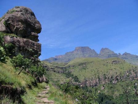 Monk's Cowl State
Forest Park was a few km up the road from Inkosana. We
had two good hikes there. Our first was a 3 1/2 hour
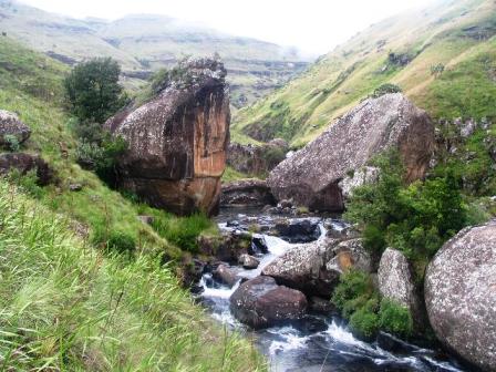
waterfall route hike to see Sterkspruit and Nandi Falls.
Monk's Cowl State
Forest Park was a few km up the road from Inkosana. We
had two good hikes there. Our first was a 3 1/2 hour
waterfall route hike to see Sterkspruit and Nandi Falls.